| Kaiaua Loop | |
| Starting point | Papakura Autobahn |
| Distance | 133 km |
| Gravel | None, but some roadworks north of Kaiaua |
| Petrol | Available at Kawakawa Bay and Kaiaua |
| Toilets | Available at Kawakawa Bay and Kaiaua |
| Lunch | Kaiaua or Miranda Road |
The Kaiaua loop is a road well-known to Auckland motorcyclists. It circles the Hunua Ranges, with the segment between Kaiaua and Kawakawa Bay the main attraction. It offers sea views, rolling countryside, and tight twisty roads. At Kaiaua there is a pub, a good fish and chip shop, and a quirky cafe called "The Pink Shop", so it's a good place to stop for lunch. At Kawakawa Bay there's a dairy which is a good place to stop for ice-cream. From central Auckland, riding the loop takes about two and a half hours.
There were major floods in the area in March-April 2017, and the road at Waharau just north of Kaiaua was closed due to slips. The damage was extensive, with parts of the road washed away. A storm in September 2018 further damaged the road. At one point, there is only one lane open, and there are several stretches of roadworks with short patches of gravel. This should not be a problem for most riders, even gravel-averse ones.
Suggested route
| Notes | Directions | Alternatives |
|---|---|---|
| Papakura BP at the Motorway Service Centre | ||
| ↓1.5 km | ||
| Drury motorway exit. Turn left onto Great South Road | ||
| ↕1.4 km | ||
| Turn right onto Sutton Road | ||
| ↕2.0 km | ||
| Turn right at the T-junction onto Ponga Road. | ||
| ↕12.1 km | ||
| Turn left at the T-junction onto Hunua Road. | Alternatively, turn right onto Hunua Road. After 2.4 km, turn left onto John Hill Road, which merges with Garvie Road | |
| ↕100 metres | ||
| Turn right onto Jones Road. | ||
| ↕1.7 km | ||
| Turn right onto Garvie Road. Garvie Road merges into John Hill Road, then becomes Sky High Road, then Monument Road. | ||
| ↕10.3 km | ||
| Turn right at a crossroads into Tourist Road | ||
| ↕1.5 km | ||
| Turn left at a crossroads onto McNicol Road. | ||
| ↕2.8 km | ||
| Turn right at a T-Junction onto Clevedon-Kawakawa Road. | ||
| ↕15.2 km | ||
| There are public toilets at Kawakawa about 100 metres before the dairy. There's a petrol station just around the corner after the dairy. The dairy has good ice-creams. | Turn right at the dairy onto Kawakawa-Orere Road. |
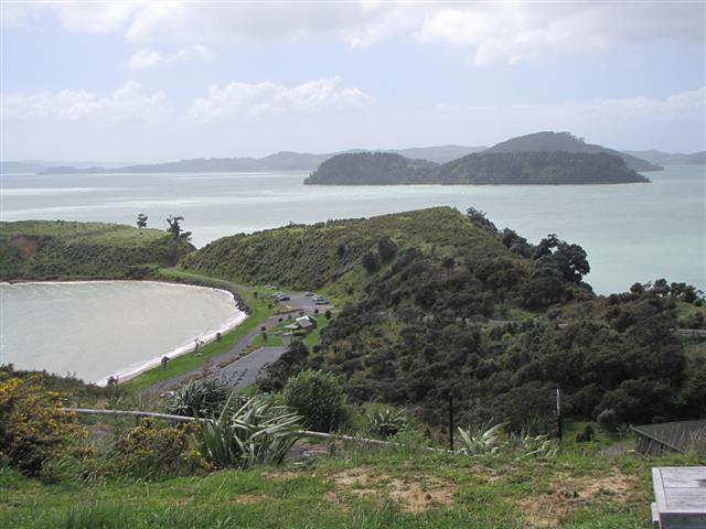
Waiatawa Regional Park is on the left 12.1 km along the Clevedon-Kawakawa Road. along the Clevedon-Kawakawa Road. A 2 km scenic road leads to a carpark with toilets and a short walk to a wharf. Instead of turning at the Kawakawa Bay dairy, continue on the Kawakawa Bay Coast Road for 4.3 km, which takes you to Waiti Bay, which has toilets. |
| ↕29.9 km | ||
| There are public toilets as you approach Kaiaua from the north. There are several places to eat at Kaiaua, and there is a petrol station. | Follow the road to Kaiua. Kawakawa-Orere Road becomes Orere-Matingarahi Road, then E Coast Road. |
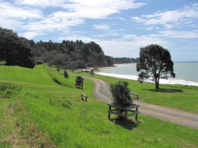
Takapakanga Regional Park is on the left 12.1 km along this road. There are 1.6 km of gravel roads to get to the park. There are toilets. About 24 km along this road (6 km north of Kaiaua) there's a shipwreck on the left. Park on the road and walk to the wreck. It's best at low tide. Information |
| ↕10.0 km | ||
| Continue south. E Coast Road becomes Miranda Road. Turn right to stay on Miranda Road although the main road continues south. | ||
| ↕14.7 km | ||
| The Miranda Farm Shop and Cafe at 1107 Miranda Road is a possible place to stop for lunch. | Follow Miranda Road and then Mangatangi Road, then turn right at an angled T-junction onto Mangatawhiri Road. | |
| ↕4.9 km | ||
| Turn right onto Lyons Road. | ||
| ↕2.6 km | ||
| Turn left onto Paparimu Road. | ||
| ↕4.3 km | ||
| Continue ahead on Paparimu Road when the main road turns right. | ||
| ↕13 km | ||
| Continue on Paparimu Road, which becomes Bombay Road then Mill Road near the end. This leaves you at a roundabout with ready access to the Southern Motorway in either direction. |
To ride this route in reverse, start at the Caltex petrol station in Bombay, which is next to the roundabout at the end of the table above. Finish at Clevedon, or continue from Clevedon for 1.1 km on Papakura-Clevedon Road, then turn right onto West Road. Follow that for 4.1 km, then turn left at the roundabout onto Brookby Road. Follow Brookby Road, Alfriston Road and Stratford Road for 8.7 km through two roundabouts. At the third roundabout, turn left onto Hill Road. Hill Road leads you to the Southern Motorway, or for a place to debrief after the ride, the Auckland Botanic Garden carpark is on the right side just before the motorway.
Photos
 |
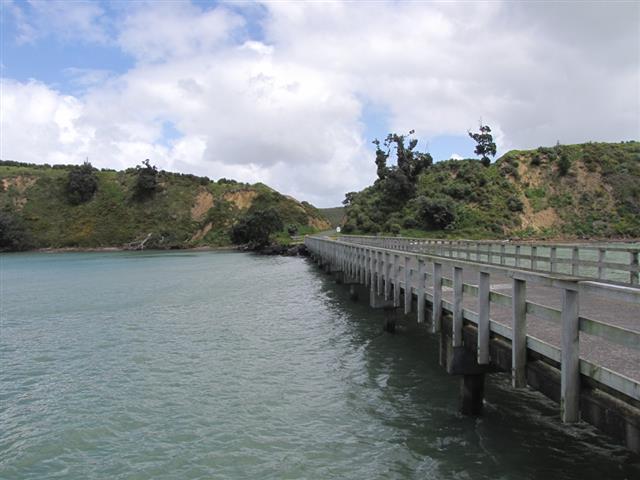 |
| View from Waitawa Regional Park over Pakihi Island | Waitawa Regional Park wharf |
 |
|
| Tapapakanga Regional Park |