| Raglan |
|
| Starting point | Papakura Autobahn |
| Distance | 228 km |
| Gravel | None |
| Petrol | Available at Pukekawa, Glen Murray, Te Uku, Raglan, Whatawhata, Ngaruawahia. |
| Toilets | Available at Raglan, Te Kowhai |
| Lunch | Raglan or Whatawhata |
State Highway 22 is a short highway connecting Pukekohe to the Southern Motorway. It's not an interesting road at all. However, it once extended through Tuakau south to connect with the road from Hamilton to Raglan, State Highway 23. About 1990, the road was truncated to its current length. The old road is still called Highway 22 (but not State Highway 22) for most of its length, and the southernmost portion is Ohautira Road. These are very nice country roads for motorcyclists, with lots of curves, little traffic especially on weekdays, and pleasant scenery.
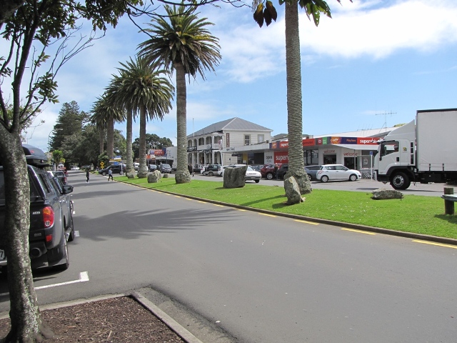
Raglan is an attractive coastal town with a good range of eating places.
Suggested route
| Notes | Directions | Alternatives |
|---|---|---|
| Papakura BP at the Motorway Service Centre | ||
| ↓1.5 km | ||
| Drury motorway exit. Turn right onto State Highway 22. | ||
| ↕750 metres | ||
| Turn left onto Great South Road. | ||
| ↕8.4 km | ||
| Immediately after passing under the motorway, continue straight ahead onto Bombay Road (Great South Road turns to the right). | ||
| ↕1.9 km | ||
| Continue straight ahead onto Razorback Road (the main road turns right and becomes Mill Road). Razorback Road becomes Helenslee Road. | 2.8 km along Razorback Road, turn right onto Nikau Road then right again onto Ridge Road once you cross over the motorway. This takes you on a twistier road which brings you out where Pokeno Road becomes Whangarata Road. There's a quarry along Ridge Road which results in large trucks using it on weekdays. | |
| ↕6.4 km | ||
| Turn right onto Munro Road. | ||
| ↕0.75 km | ||
| Turn right onto Pokeno Road. Pokeno Road becomes Whangarata Road. | ||
| ↕7.0 km | ||
| Turn left onto River Road. | ||
| ↕3.3 km | ||
| After crossing the Waikato River, turn right onto Highway 22. | ||
| ↕62.0 km | ||
| There are petrol stations at Pukekawa and Glen Murray on Highway 22. | Turn right onto Ohautira Road. | |
| ↕17.4 km | ||
| Turn right onto State Highway 23. The road becomes Main Road and then Bow Street as you enter Raglan | For a shorter ride (saving 25 km), turn left onto SH23 and go to Whatawhata for lunch instead. | |
| ↕12.6 km | ||
| There's a petrol station at Te Uku on State Highway 23. There's petrol, public toilets, cafes and a bakery at Raglan. | Arrive at Raglan. Leave on the same road you came in on. | Turn right onto Te Mata Road 5.6 km along SH23 to Bridal Veil Falls. The carpark for the falls is 12.8 km from this junction. There's a short walk from the carpark to the top of the falls, and a further steep walk to the base. |
| ↕33.2 km | ||
| Thre's a petrol station at Whatawhata and a couple of cafes. The public toilets closed in 2017. | Turn left at Whatawhata onto State Highway 39. | |
| ↕14.2 km | ||
| Turn left onto Horotiu Road, which becomes Ngaruawhaia Road and then (as you approach Ngaruawahia) Whatawhata Road. | ||
| ↕10.9 km | ||
| There's a BP petrol station on the right at this intersection. | Turn left onto Ellery Street. | |
| ↕150 m | ||
| Turn at the first right into Herschel Street. Continue through the roundabout. Herschel Street becomes Waingaro Road. | ||
| ↕1.2 km | ||
| Turn right onto Hakarimata Road, which becomes Riverview Road. | ||
| ↕13.7 km | ||
| In Huntly, continue straight through the roundabout onto Harris Street. | ||
| ↕2.1 km | ||
| Turn right onto Te Ohaki Road, which turns right and becomes Glen Murray Road. | ||
| ↕13.9 km | ||
| After crossing the Waikato River, continue straight through the roundabout onto Te Kauwhata Road. | ||
| ↕1.9 km | ||
| Turn left at the roundabout, then right to join State Highway 1 north. | ||
| ↕21.6 km | ||
| There's a petrol station at Mercer, and another at Pokeno. | Take the Pokeno exit from the motorway. Have an icecream and debrief after the ride. | |
To ride this route in reverse, follow the motorway south to Rangiriri, go right at the roundabout, and cross the Waikato River. At the end, continue along Pokeno Road for the icecream and debrief instead of turning up Munro Road.
Photos
 |
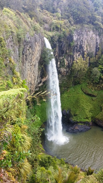 |
| Raglan | Bridal Veil Falls |